Submitted proposals
Key information about the scheme
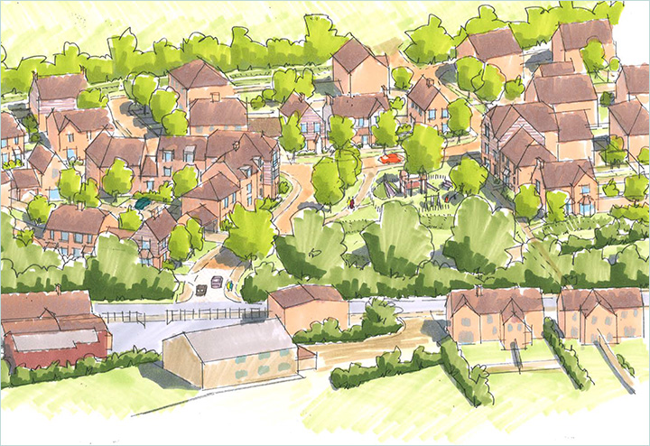
Following consultation with the Council, local stakeholders and residents, Welbeck Land’s submitted proposals include new market and affordable homes in Rudgwick, as well as promotes sustainable living through public open green space, a new play area, community orchard and new footpaths enhancing connectivity.
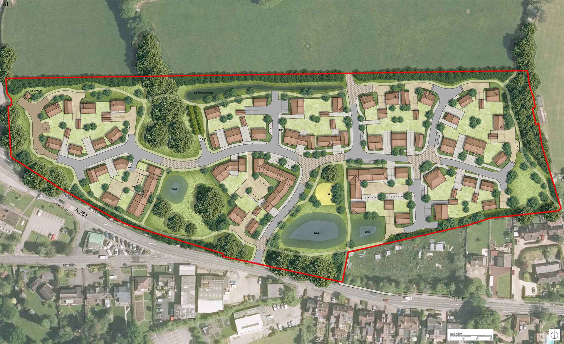
Submitted masterplan
Key features
Benefits for people and place
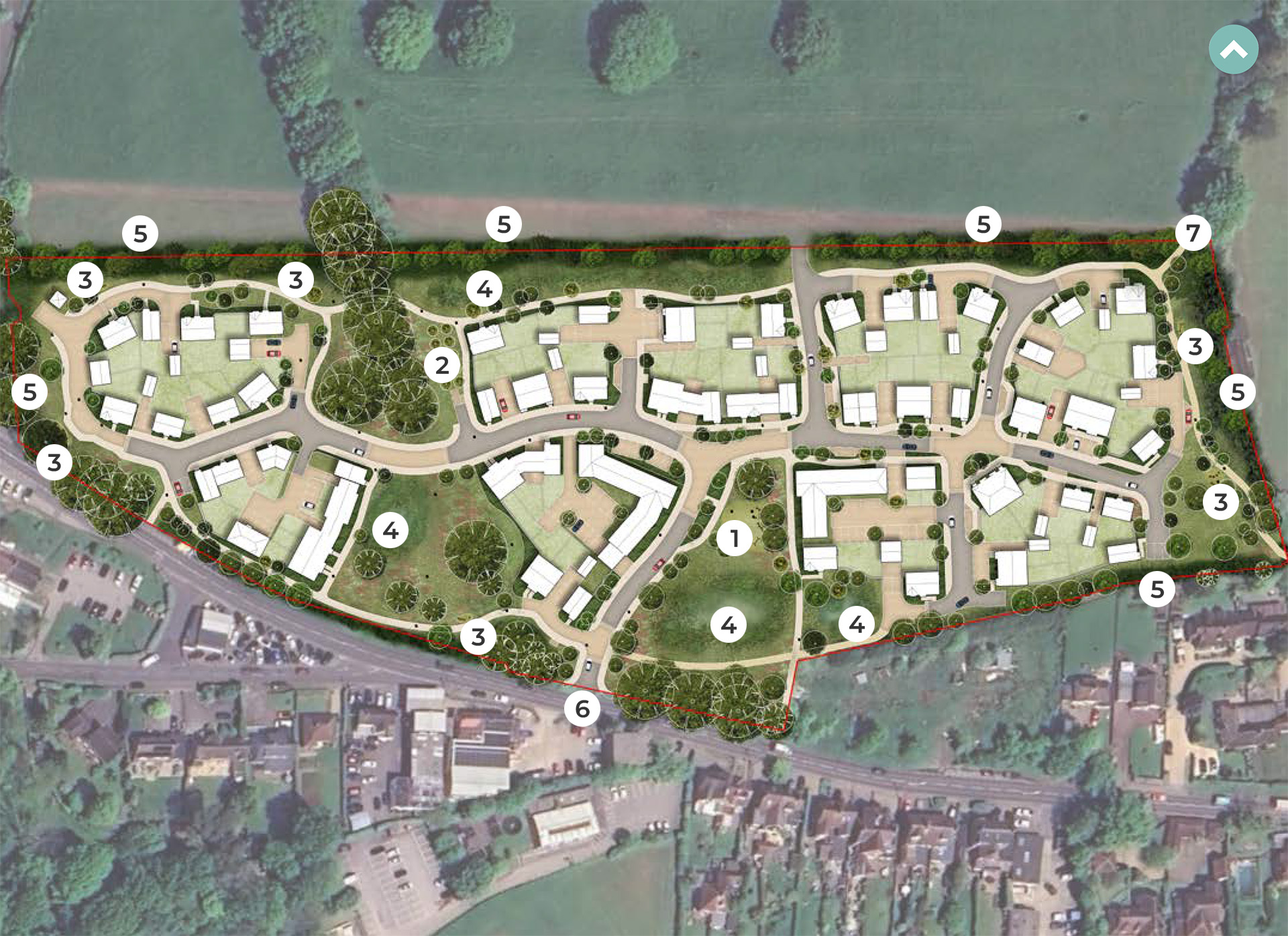
- Up to 90 high-quality new homes to meet the housing needs of Rudgwick.
- 40% will be classed as affordable to enable residents to get onto the housing ladder.
- A mix of house types and tenures to respond to the needs of the local community.
- Landscape led public open spaces for all to enjoy, including a community orchard, play areas, and a play trail fostering community and recreational activities.
- Protection and enhancements to existing green infrastructure.
- New and improved walking, cycling, and public transport links to promote sustainable active travel throughout the site and beyond.
- At least a 10% biodiversity net gain.

New homes
High-quality housing that meets local needs
The proposals seek to deliver up to 90 high-quality new homes, in a range of house types, sizes and tenures, seeking to address identified local need in Rudgwick.
As part of the proposals, 40% of affordable housing will be provided in varying sizes and tenures including affordable rent, shared ownership, and First Homes, offering a range of options for residents looking to get onto the housing ladder.
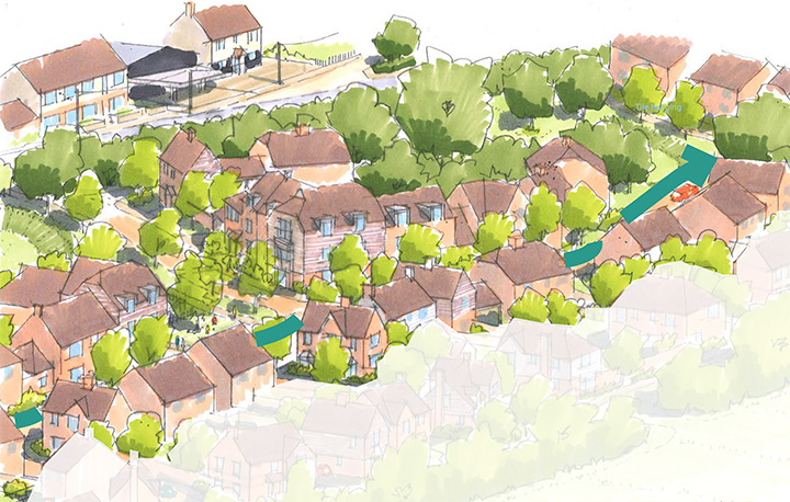
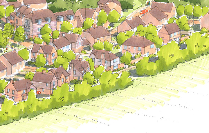
The new homes will be designed to not only complement the local area but also to allow the development to establish its own distinct sense of place, helping create a community. Most homes will be two storeys, with steeply pitched roofs in a cottage style, while a small number of apartments will be designed as large country houses, blending into the village setting.
A carefully chosen palette of traditional materials will reflect the local character, including red/orange and painted brick, tile hanging, plain tile roofs, and white weatherboarding.
As set out above, the proposals will be submitted under an outline application to establish the principle of new homes in this location, with detailed design coming forward at a later stage as part of a Reserved Matters application.

Character areas
Three character areas for new homes
The proposals include three character areas for the new homes proposed which include:
Entrance Gateway
The entrance along Guildford Road will create a welcoming arrival, reflecting the village’s existing linear settlement pattern while retaining mature trees and hedgerows where possible. A mix of house types, including terraces, semi-detached and detached homes, together with two small apartment buildings, will frame green spaces and mark key points of focus. Parking will be carefully designed and landscaped to keep the streets attractive and green.
Central Street
Running through the heart of the development, the central street will echo the feel of a traditional village lane, with gentle curves, grass verges and tree planting. It will connect key open spaces at either end, improving links with the wider village. Homes here will mainly be two-storey houses, with varied spacing to avoid uniformity and maintain a semi-rural character. Parking will be mostly on-plot, with small areas of well-designed on-street provision.
Green Edges
The outer edges of the development will blend into the surrounding countryside, with generous planting buffers, hedgerows and tree planting creating a soft, natural boundary. Homes here will have a more informal layout, with detached and semi-detached houses set within green spaces to create a rural character. Parking will be integrated into plots or garages to keep the streets open and uncluttered.
Landscape-led scheme
Prioritising public green open space for all to enjoy
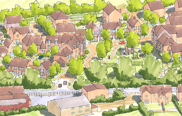
Our development is not just about homes but also about creating vibrant community spaces.
As part of the proposals, Welbeck Land is proposing to retain end enhance as much existing flora and fauna as possible, prioritising the protection and enhancement of the existing landscape.
Within both proposals, existing vegetation along the southern site boundary would be extended and reinforced to provide a strong landscape and visual buffer along Guildford Road. Additionally, a tree belt along the northern site boundary is proposed to screen the site from the open space to the north. An existing green corridor crosses the site from north to south, where existing trees will be retained and become a key element in protecting and enhancing biodiversity onsite.
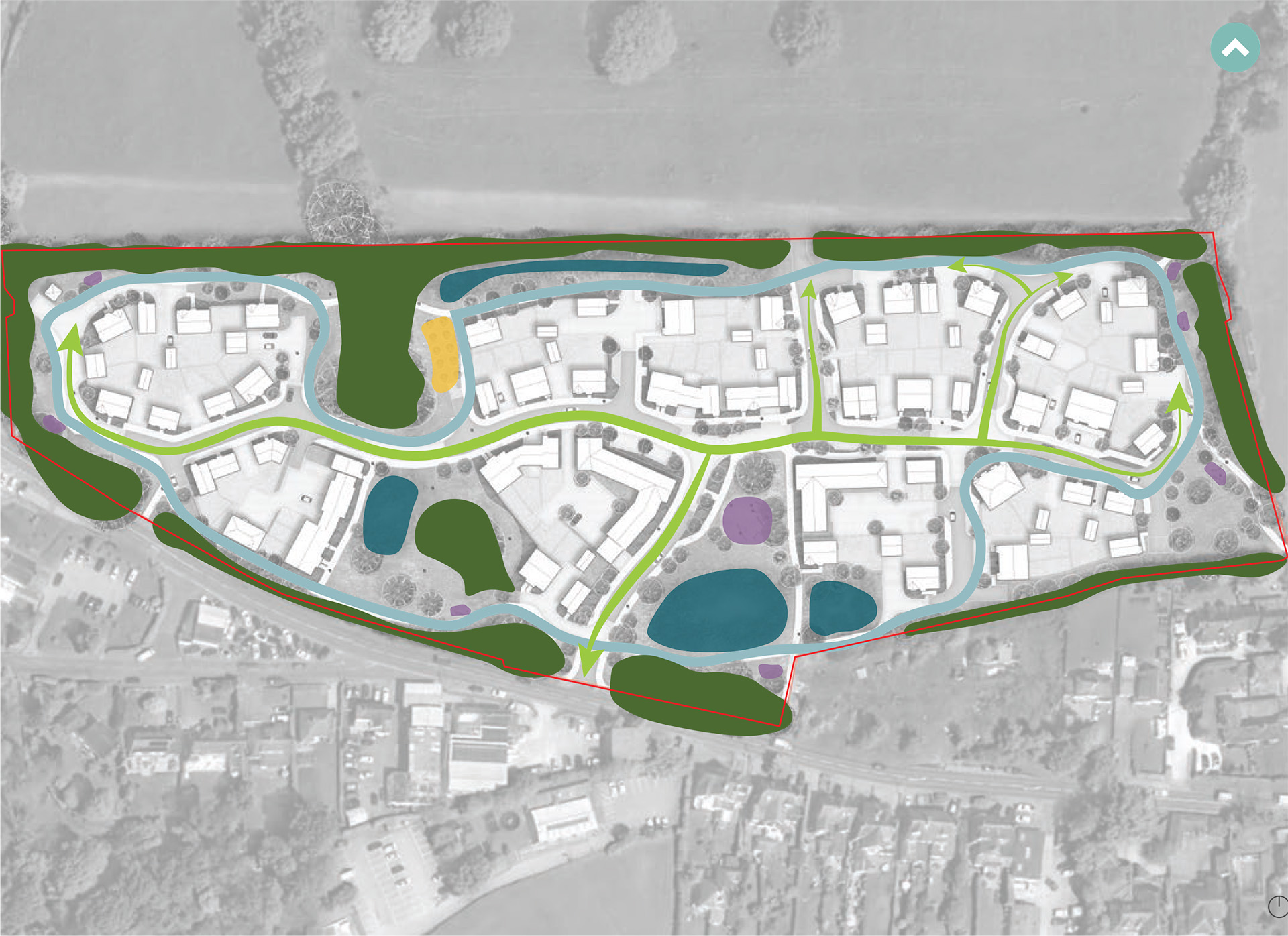
Different features are proposed within the open space, including a community orchard, a play area and play trail for the community to enjoy.
 Play space & green open space
 Orchard
 Trim trail
 SuDs / Attenuation zone
 Native tree / shrub belt
 Entrances
 Connection to PROW
Landscaping proposals
Creating vibrant community spaces
The site is divided into a series of landscape character areas as a mechanism to distinguish the different areas of the site.
These landscape character areas including the following, which can also be seen on the plan to the right:
- Green Streetscape
- Orchard
- Green Open Space & Play
- Fitness Trails
- Sustainable Drainage Systems
- Structural Vegetation
A structured palette of materials and planting will be used across the different character areas to provide differing characters but still create visual unity and a cohesive landscape design.
 Green Streetscape
 Orchard
 Green Open Space & Play
 Fitness Trails
 Sustainable Drainage Systems
 Structural Vegetation
Active travel
Fostering active living in Rudgwick
Welbeck Land has designed the proposed development with health and well-being at its core, providing numerous opportunities for residents to lead active and healthy lives.
In addition to the main access point, there will also be multiple pedestrian and cycle access points throughout the proposals. These propose to connect to the wider Public Rights of Way network, enhancing connectivity and reducing the reliance on cars for those living within the development and nearby the open space.
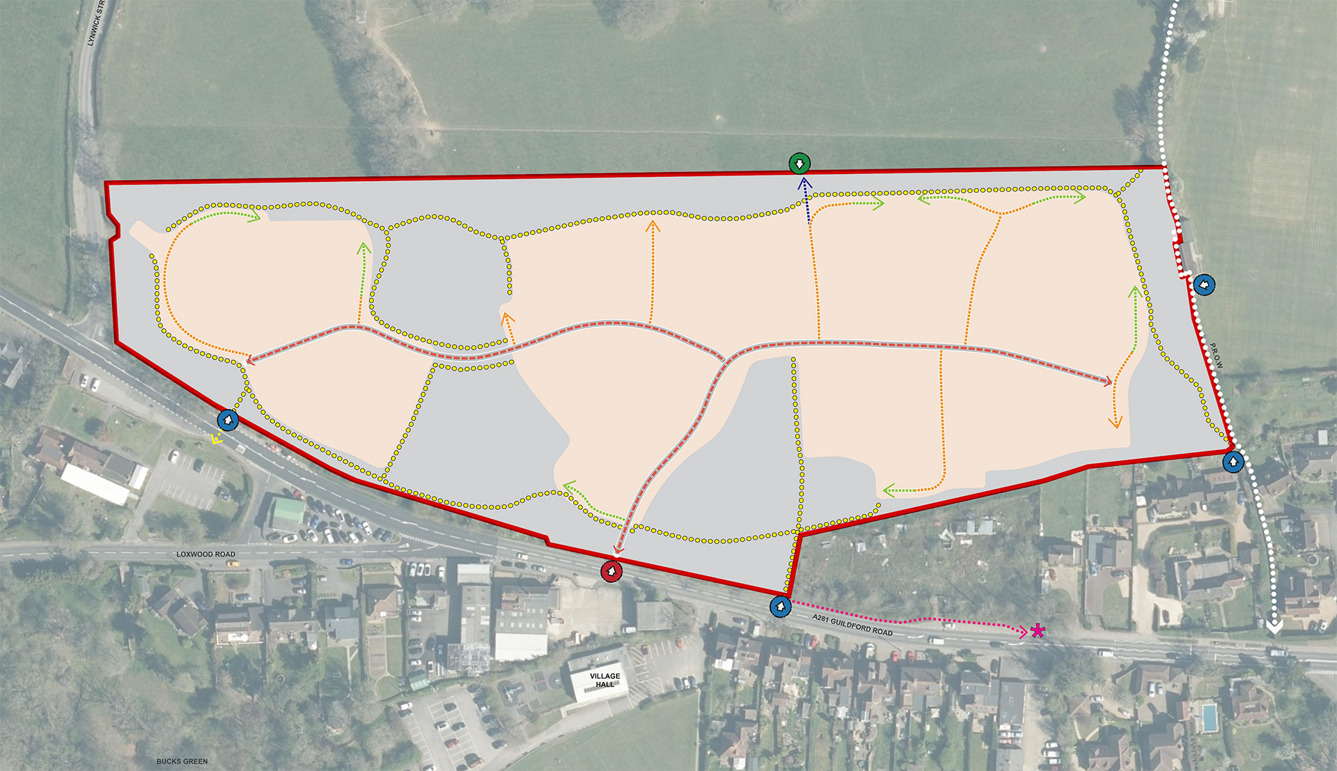
 Site Boundary
 Proposed Vehicular Site Access
 Retained Field Access
 Proposed Pedestrian Access
 Indicative Location of Primary Access Road
 Indicative Location of Secondary & Tertiary Streets
 Indicative Location of Edge Streets
 Field Access
 Developable Area
 Public Right of Way (P.R.O.W)
 Indicative Location of Proposed Footpaths
 Proposed Pedestrian Footpath & Crossing Point
 Proposed Pedestrian Footpath Access to Bus Stop
 Existing Bus Stop
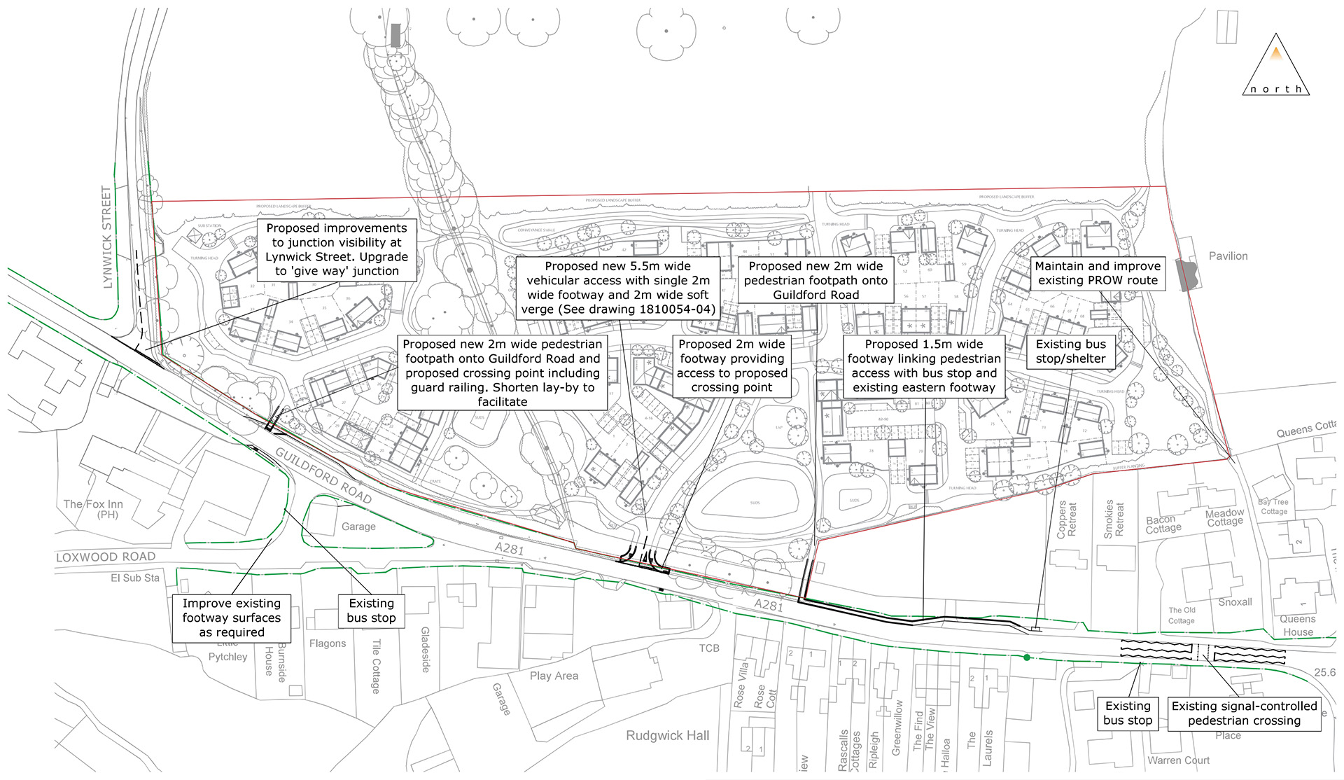
Site access
Carefully designed access arrangements
The vehicular access point for the development is proposed through the creation of a new access to the south of the site off Guildford Road to leading to a primary movement corridor to the new homes, connecting to secondary and tertiary streets.
This access point will be a priority junction with a 6m junction radii and a 2m footway on both sides of the access, complying with the standards required. In addition to this access, an agricultural field access is safeguarded to the north of the site.
Additional opportunities for improvement include:
- A new footway along the northern side of the A281 connecting the proposed eastern pedestrian access to the existing pedestrian network and bus shelter to the east
- A minor amendment is proposed to the existing lay-by on Guildford Road to facilitate one of the proposed crossing points from the development.
- A new uncontrolled pedestrian crossing comprising dropped kerbs and tactile paving approximately 50 metres to the east of Lynwick Street (and requiring amendment to the existing lay-by).
- A new uncontrolled pedestrian crossing located to the immediate east of the proposed site access junction connecting to the existing footway on the southern side of Guildford Road.
- Sightline improvements at the junction of Lynwick Street and Guildford Road to comprise the cutting back of vegetation.
 Site boundary
 Highway boundary
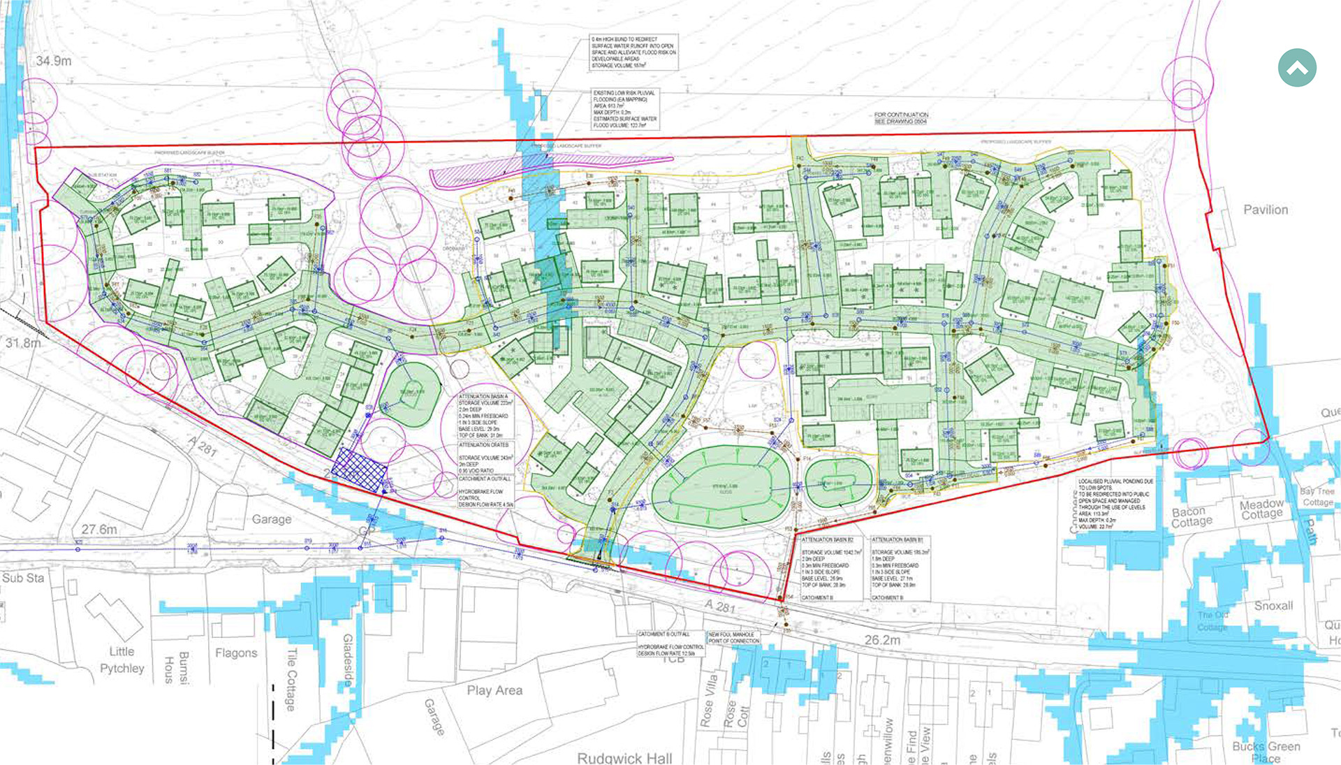
Flood mitigation
Sustainably designed to help prevent flooding
The proposals have been designed to effectively manage surface water and the site is located entirely in Flood Zone 1, meaning it is classified as being at low risk of flooding from surface water.
The surface water drainage strategy involves capturing surface water runoff at its source and retaining it on site within attenuation ponds, which would form an attractive feature within the development managing surface water and contributing to biodiversity at the site. The water would then be discharged into the existing watercourse located west of the site adjacent to Loxwood Road.
The surface water drainage strategy will not only restrict flows to greenfield rates, but also significantly reduce peak flows compared to the existing situation, thereby effectively reducing the risk of flooding downstream.
In regard to foul water, there is a public foul sewer on Guildford Road into which it is anticipated that foul water from the development can be discharged. Southern Water have confirmed there is existing capacity to accommodate foul flows from the development and this connection will be subject to a Section 106 agreement.
 Planning application boundary
 Surface water sewer
 Foul water sewer
 Surface water chamber
 Hydrobrake
 Foul water chamber
 Headwall
 Attenuation crates
 Root protection areas
 Attenuation basin
 Risk of surface water flooding
 Surface water retention bund
 Catchment A – Total area: 0.66ha
 Catchment B – Total area: 2.06ha
 Drainable areas
Commitment to sustainability
Supporting a sustainable future
In accordance with local and national policies, the proposals have been developed with sustainability at their core. The new homes and green spaces will help create a community that’s energy efficient, climate-friendly and future-ready through the following methods:
- Low carbon homes – all homes will be ‘zero-carbon ready’ built to high fabric standards to meet Future Homes Standard requirements, with no gas connection, with energy instead coming from cleaner, greener sources.
- Climate resilience – the homes will be designed to stay cool in summer and warm in winter, and green spaces and landscaping will provide places to enjoy nature while helping to manage rainwater naturally.
- Water neutrality – Homes will feature water-saving fixtures and rainwater collection to reduce everyday use and any remaining water demand will be balanced through the Council’s SNOWS scheme, helping the development achieve water neutrality.
- Greener Travel – the proposals will provide easy access to walking, cycling and public transport options, with electric vehicle charging points provided throughout the development.
- Reducing Waste – The development will use sustainable materials and recycle wherever possible and careful construction methods will be used to reduce waste and the project’s overall carbon footprint.